Tourist Map of Belize

A map of Belize allows you to see this beautiful country whether you are renting a car, taking a shuttle or driving yourself. We have included several maps showing the Cayes (coral island), Villages, Towns, City in the districts of the country. To reach the major islands, namely Caye Caulker and Ambergris Caye, you will either need to take the Water Taxi or a Plane to get to these places. Belize’s location makes it a part of both Central America and the Caribbean. This is evident as you walk among the people of the amazing nation.

Belize’s bordering countries are Mexico to the north and Guatemala to the west and south.

Looking at the map of Belize City you will see that the only international Airport located a few minutes away from Belize City is the Village of Ladyville. nevertheless, the airport is still sighted as being in Belize City.

Highways and Popular Area on Belize Map

maps of belize highways
Ambergris Caye

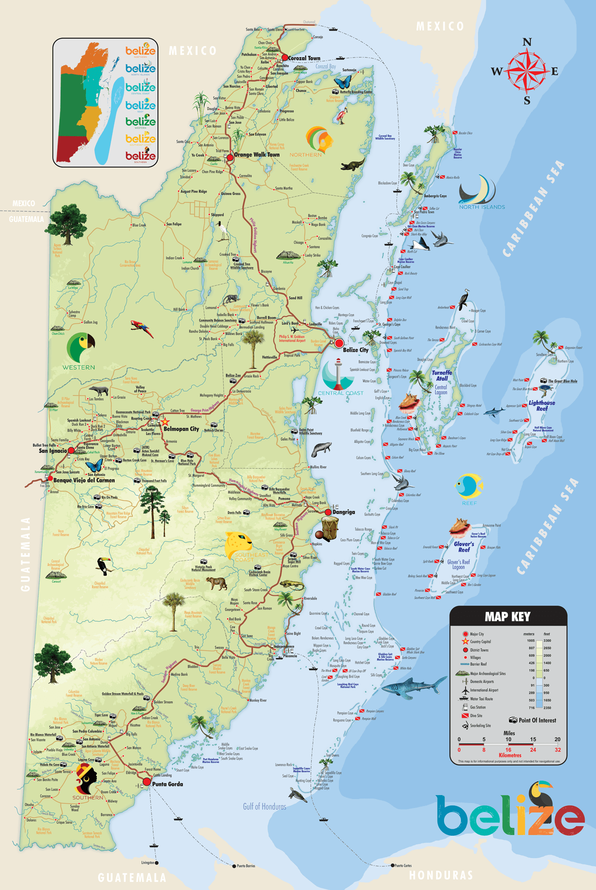
Ambergris Caye located a mile from the Belize Barrier Reef and other marine reserve are the Top destinations for tourist, many go to enjoy the beaches before or after travel vacation inland.

Caye Caulker
Add Your Tooltip Text Here
Belize City

Both inland and sea tours can be done from this location. Visit the Crooked Tree Wildlife Sanctuary or the many archeological sites near by.

Belmopan City
Add Your Tooltip Text Here
San Ignacio

San Ignacio and Santa Elena Town located about 85 away from Intl Airport and Main airport, is a popular destinations for tourist and locals. Here you can travel a bit further and do the Tikal tour before returning to Belize.

Dangriga

Dangriga Town located in the Stann Creek District is your gateway to Tobacco Caye or South-water Caye.

Hopkins Village
Hopkins is location along the coast, south of Belize City, about 113 Mile (183Km Driving). Hopkins is a tourist destination you can drive yourself.
Placencia

Placencia is location south of International Airport, about 145 Mile (233Km0 Driving). In many Belize Travel Guide you will be Placencia is a Sea and Jungle Destination.

Punta Gorda

Punta Gorda is the least visited of the major cities in Belize.

Table of Contents

Map of Belize City

Belize City is the economic capital of the country and was once the location of the Capital. The city played an important role when Belize was owned or governed by the British.

As you will see from the Map of Belize City, there is where you will take the Watertaxi’s to either Ambergris Caye or Caye Caulker. 

The Phillip S.W Goldson International Airport is not in Belize City itself but is located about 15 minutes away.

Explore Google Map of Belize

Before visiting the country, I would recommend exploring Google Map of Belize. Although Belize is a small place in Central America, many of the roads aren’t paved. This can increase drive time by 2 or more hours. With that said, using Google Map can help you map out your vacation or locate new places to stay or tour.

Our shuttle team hopes these Maps of Belize help improve your vacation plans.

We thought about including a political map of Belize but decided not to bring politics into this. It’s best we try to help you have the best time in the country when travelling from North America and around the world.

William Shuttle Service connects you to all corners of Belize, explore the map with us as we drive you along many of Belize’s beath-taking highways and roads.  Discover a few places you won’t find on any map of Belize or its districts and villages.